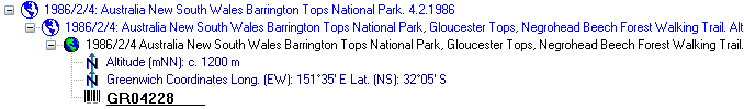
 icon in the tree as shown below.
As additional
information to the description of the locality you
can use several localisation
systems, e.g. georeferencing. These entries
are marked with an
icon in the tree as shown below.
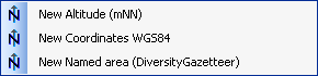
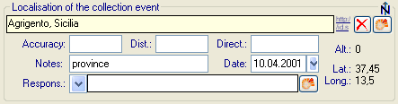
To add a new entry choose the localisation system from the drop-down list as shown below. Only items which are not already set for a CollectionEvent will be shown. The items visible in the drop-down list can be customized.
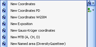
If a localisation should
be removed, select it from the list and
click on the  button.
To define an area for the locality you can use the GIS editor. For further details please see the help sections for the corresponding pages.
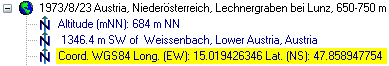
If you use geo-coordinates as
georeferencing system (coordinates WGS84),
a button  will appear which will provide you with the
possibility to set or correct the coordinates
via Google Maps. Just click on the
button and a window will open with a map provided by
Google
Maps as shown below. If there are already
coordinates provided by a different localisation
e.g. by the DiversityGazetteer, these will be taken as a
starting position. Thus, you
may use an entry for a named area (DiversityGazetteer) as an
approximate localisation
and use additional coordinates for a more accurate localisation.
will appear which will provide you with the
possibility to set or correct the coordinates
via Google Maps. Just click on the
button and a window will open with a map provided by
Google
Maps as shown below. If there are already
coordinates provided by a different localisation
e.g. by the DiversityGazetteer, these will be taken as a
starting position. Thus, you
may use an entry for a named area (DiversityGazetteer) as an
approximate localisation
and use additional coordinates for a more accurate localisation.
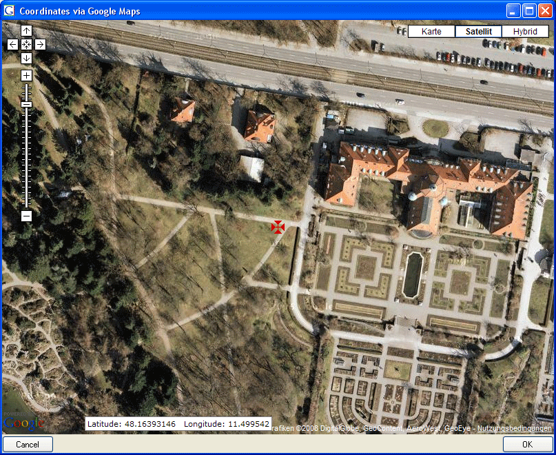
If you start with existing geographic
coordinates (WGS84) in your data, the system will
use these as starting point. You can zoom the map,
drag it to another
position and change from map to satellite mode. The
actual position is
symbolized by the  symbol in
the middle of the map. The current
coordinates are shown in the field
at the bottom of the map. To include these
coordinates in your data simply click
OK.
symbol in
the middle of the map. The current
coordinates are shown in the field
at the bottom of the map. To include these
coordinates in your data simply click
OK.
With the
Set start coordinates button you can set the coordinates
which GoogleMaps
should use as a starting position.
Please keep in mind that Google Maps coordinates are based on WGS84.
If there are no entries for the altitude and the named area, this data will be retrieved from the webservice ws.geonames.org and entered into the database. The source will be documented in the Notes field. Subsequent changes in the coordinates using the GoogleMaps function will update the altitude and named area entries provided they are derived from a webservice (ws.geonames.org) as documented in the Notes field.
To enter the localisations listed above simply enter the Coordinates WGS84. If an appropriate webservice is available (e.g. geonames) the Altitude and Named area will be added automatically.
The localisation system DiversityGazetteer is linked to the module DiversityGazetteer within the DiversityWorkbench and providing information on geographical names as shown below. The module DiversityGazetteer may contain several independent lists of geographical names, e.g. political and biogeographical regions. You therefore may add up to 5 links to the module DiversityGazetteer.
The source data for TK maps are stored in the module DiversityGazetteer. You need an access to a database of this module
containing these data. If you choose MTB or TK25, the button will open a window
where you can set
the TK25 as well as the quadrant (see image below). Choose the
quadrant
depending on your preferred resolution. The thick line shows the
current
quadrant, the thin line the entire TK25. The needle in the
center is placed at your
current position. If you click on it, a message box will display
the TK25
information as shown below.
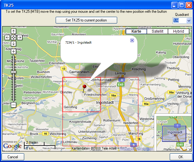
If you click [OK], the TK25 values together with the coordinates of the center of the selected quadrant will be entered into the database.
The values for any localisation system are stored in two text fields. You can enter your values as simple text. This may, however, prevent any calculations with said values. Thus, you should preferably enter your values according to the measurement units available. Whatever obsolete measurement units like feet or Fahrenheit may exist, within the DiversityWorkbench measurement data is stored in units according to the Système International d'Unités (SI). For those who still need to use these obsolete units DiversityCollection provides a possibility to convert them into their modern counterparts. To enter a numeric value choose the unit you prefer from the list. The form will change as shown below.

You can then edit the values and click on the  button to incorporate the changed values into your
data. The system will calculate
the corresponding value for storage in the database
together with the default
accuracy. You may correct this accuracy if you have
more exact values. To indicate that
the shown values are calculated from the values in
the database the fields have
a green background. When you save the data
DiversityCollection will store
geographic coordinates and the average altitude, if available,
in separate
fields.
button to incorporate the changed values into your
data. The system will calculate
the corresponding value for storage in the database
together with the default
accuracy. You may correct this accuracy if you have
more exact values. To indicate that
the shown values are calculated from the values in
the database the fields have
a green background. When you save the data
DiversityCollection will store
geographic coordinates and the average altitude, if available,
in separate
fields.
The altitude, the exposition or the slope may be entered as one value or as a range of two values. If you use the conversion function and have only one value, make sure that the second field is empty.
 Available units: meter and feet.
 Available units: Orientation (N, NE, ... ) and degree rel. to
North.
Available units: Orientation (N, NE, ... ) and degree rel. to
North.
 Available units: degree and percent.
The accuracy and uncertainty respectively will be calculated as an approximation in parts derived from Wieczorek, J. 2001 (MaNIS/HerpNet/ORNIS Georeferencing Guidelines. University of California, Berkeley: Museum of Vertebrate Zoology) and in parts according to Wieczorek, J., Q. Guo, and R. Hijmans 2004 (The point-radius method for georeferencing locality descriptions and calculating associated uncertainty. International Journal of Geographical Information Science 18: 745-767). The unit of the accuracy will always be the unit stored in the database according to the Système International d'Unités (SI) and degrees for angles respectively.
The data for the geography is stored in the table CollectionEventLocalisation.